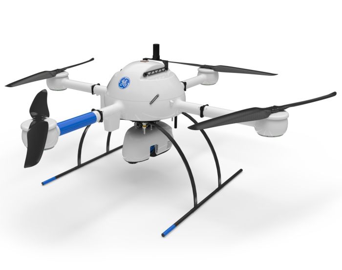
Microdrones GE Industrial mdLiDAR1000HR NDAA Compliant
Quick Overview
Introducing the mdLiDAR1000HR Traditional NDAA Compliant drone with High Resolution Velodyne Payload. By combining the robust and field proven md4-1000 airframe, with a fully integrated high-resolution LiDAR & camera payload from Velodyne, the mdLiDAR1000HR can capture ultra dense LiDAR data quickly and safely in the field. The Velodyne LIDAR payload utilizes the new Puck Lite sensor which offers increased range and field of view.
HR means high resolution pointclouds and increased coverage is made easier and more accessible than ever. This is the UAV, hardware, software, workflow, training and support that surveying professionals need. It includes a perpetual license of LP360 Drone software for post-processing your data. LP360 Drone is a powerful ecosystem that will enable you to quickly and efficiently process geospatial data. Your system will include LP360 Drone, as well as Strip Align and Desktop Photo Add-Ons.
Specific RC and software make this system NDAA Compliant for any projects with NDAA requirements.
ONLY AVAILABLE FOR DELIVERY IN TEXAS, OKLAHOMA, NEW MEXICO AND ARIZONA.
SKU
A005628
In stock

LIDAR + mdaaS + EASY TO USE mdInfinity SOFTWARE = EXTREME GEOSPATIAL PRODUCTIVITY, NOW IN HIGH RESOLUTION
Microdrones has developed an end-to-end LiDAR solution combining a drone, a LiDAR payload, a fully integrated LiDAR processing and photogrammetry software workflow, and world class support to consistently provide quality deliverables.
mdLiDAR1000HR aaS is a fully integrated system for producing 3D point clouds optimized for land surveying, construction, oil & gas and mining applications.
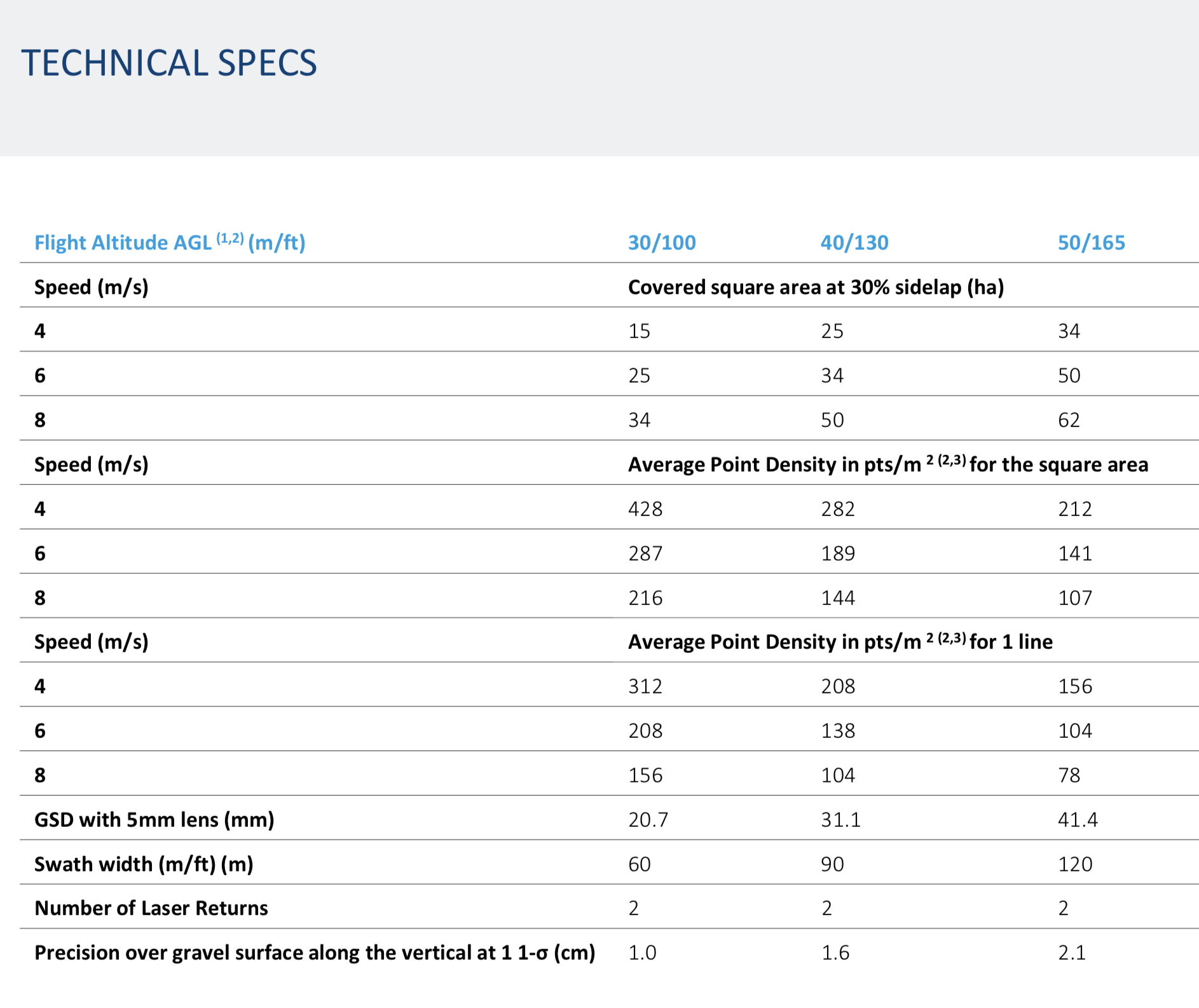
mdLidar1000HR aaS with a 90 degree field of view for both scanned points and imagery, repeatedly provides a precision of 1.6 cm (.052 ft) at 1-σ when flown at 40 m (130 ft) at a speed of 8 m/s (18 mph).
The improved image acquisition precisely configured to match laser scanner field of view of (90 degrees) also enables compatibility with the streamlined point cloud colorization and FORMap data processing modules within the mdInfinity platform.
Each LiDAR channel of the mdLiDAR1000HR was boresight calibrated to improve the data consistency, therefore providing a reduced Standard Measurement Uncertainty.
Who Should Consider This System:
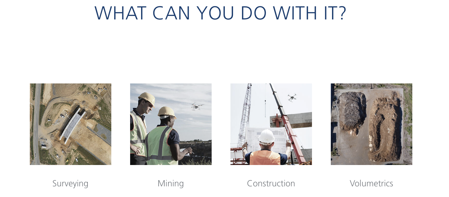
Professionals responsible for geospatial data collection should consider mdLiDAR1000HR aaS to support the following tasks.
- Corridor mapping
- Mining (volume calculation)
- Construction site monitoring
- Environmental changes (time series)
- Forestry
- Contour mapping
- Planning, Leveling, Excavation
- Archaeology and cultural heritage
- Highway construction
- Precision Agriculture
5 REASONS WHY PROFESSIONALS ARE MAKING THE mdLiDAR1000HR aaS PART OF THEIR GEOMATICS WORKFLOW:
1. Drones Can Lead To Better Worker Safety
Easily tackle projects in areas that are difficult, dirty or dangerous to access – such as challenging terrain, crumbling structures, high elevations, and areas impacted by natural disasters.
2. Save Time, Money And Hassle By Deploying A Drone
Collecting data previously required extensive groundwork or very expensive manned aircraft. Using a drone allows quick and affordable data collection; that’s one of the most important benefits for geospatial professionals.
3. Integrated Drones = Interruption-Free Data Collection
Survey live construction or mining sites without interrupting people, plans or machinery. You’ll no longer have to stop work and equipment to collect the data you need, making you more valuable to your customers.
4. Technology Thought Leadership And Practical Field Leadership
Customers are curious about UAV surveying technology – so providing it demonstrates that a business is an industry leader at the helm. Faster, more efficient data collection differentiates you from competitors and positions you as a subject matter expert in an emerging technology.
5. Microdrones Offers Unmatched Training, Education And Support
Our professional UAV pilots offer complete onsite Microdrones UAV training to both dealers and end-user customers to ensure they are fully capable of deploying their drone packages in the field, ready to achieve immediate results.