877.309.4099
 Contact Sales
 877.309.4099
 Contact Sales
-
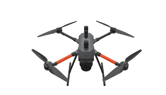
THE MOST COMPACT SURVEY-GRADE DRONE LiDAR SURVEYING EQUIPMENT ON THE MARKET: EasyOneLiDARUHR+ EasyOne LiDAR UHR+ offers some significant upgrades to the UHR and UHR Lite. The Hesai Pandar M2X sensor adds an additional return for impressive density and 40 m of increased range while holding the same accuracies. ultra-high resolution via a 32-channel LiDAR sensor, fully integrated with an improved 72.5° field of view camera. This translates to more point density, better detail, and improved deliverables. The survey equipment, LP360 Drone software, workflow, training, and support work together to make you more productive than ever. Built upon Microdrone’s 4th-gen drone technology, all EasyOne systems are more compact, more optimized, lighter, safer and more efficient. This system delivers integration unmatched in the drone surveying industry, making it easier than ever for you to plan, fly, collect, process and visualize your geospatial data projects. It includes a perpetual license of LP360 Drone software for post-processing your data. LP360 Drone is a powerful ecosystem that will enable you to quickly and efficiently process geospatial data. Your system will include LP360 Drone, as well as Strip Align and Desktop Photo Add-Ons. ONLY AVAILABLE FOR DELIVERY IN TEXAS, OKLAHOMA, NEW MEXICO AND ARIZONA. CONTACT SALESPERSON HEREQuote Now
-
MICRODRONES’ BEST LiDAR PAYLOAD FROM THE 1000 SERIES, NOW AVAILABLE ON OUR NEW AIRFRAME: EasyOneLiDARUHR & UHR LiteSMALLER, SAFER AND EASY TO USE EasyOne LiDAR UHR means ultra-high resolution via a 32-channel LiDAR sensor, fully integrated with an improved 72.5° field of view camera. This translates to more point density, better detail, and improved deliverables. The survey equipment, LP360 Drone software, workflow, training, and support work together to make you more productive than ever. Built upon Microdrone’s 4th-gen drone technology, all EasyOne systems are more compact, more optimized, lighter, safer and more efficient. This system delivers integration unmatched in the drone surveying industry, making it easier than ever for you to plan, fly, collect, process and visualize your geospatial data projects. It includes a perpetual license of LP360 Drone software for post-processing your data. LP360 Drone is a powerful ecosystem that will enable you to quickly and efficiently process geospatial data. Your system will include LP360 Drone, as well as Strip Align and Desktop Photo Add-Ons. Don’t need the full resolution of 32-channel UHR? We offer a cost competitive UHR Lite configuration, delivering 16 channels of LiDAR that can easily be upgraded later via a firmware update. ONLY AVAILABLE FOR DELIVERY IN TEXAS, OKLAHOMA, NEW MEXICO AND ARIZONA. CONTACT SALESPERSON HEREQuote Now

Item added to your cart