877.309.4099
 Contact Sales
 877.309.4099
 Contact Sales
-
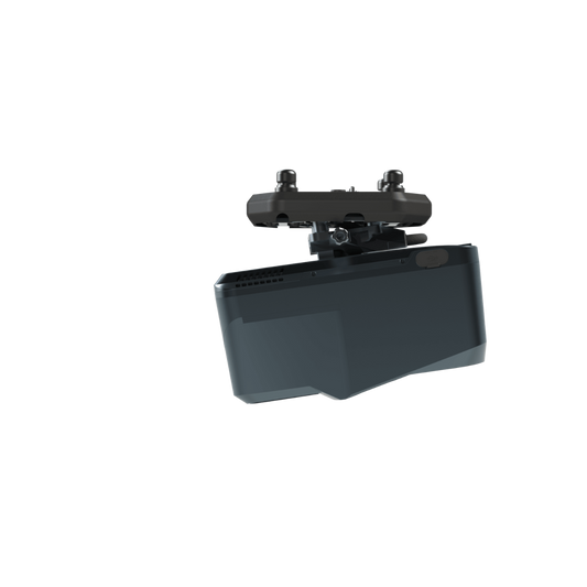
WingtraRAY redefines aerial surveying by guaranteeing mission success on the very first flight—whether you’re navigating tight urban corridors or vast rural expanses—while dramatically cutting turnaround times and operational overhead. Its modular, all-in-one design scales effortlessly from millimeter-level inspections to large-area mapping, so you can serve more clients and tackle a wider range of projects with a single versatile platform.Quote Now
-
GeoCue and CHC Navigation bring the most efficient and flexible high-end LiDAR to North America with the new TrueView 540. This next generation of LiDAR elevates our mid-range sensor line, offering enhanced density, improved accuracy, and precision, thereby producing a superior point cloud. The TrueView 540 provides users with a Engineering grade sensor powered by LP360 at a mid-range price, marking a significant advancement in LiDAR accessibility and performance.Quote Now
-
Request for Quote
TrueView 539 - Delivering Engineering-Grade Accuracy and Precision in a Lightweight
Building on the success of the TrueView 540, the new TrueView 539 brings advanced engineering-grade surveying capabilities to a wider range of aerial mapping professionals. Designed for those who demand high-quality LiDAR performance in a more affordable package, the TrueView 539 delivers precision and flexibility without compromise.Quote Now -
Freefly’s latest commercial drone platform with Sony LR1, Pilot Pro, Doodle Labs Radio, RTK, LTE cloud connectivity, mission computer, AuterionOS and more. Astro is backed by the team at Freefly with 100,000+ successful commercial & drone flights.Quote Now
-
Astro Max is Freefly’s ultimate compact industrial drone platform. This model has special hardware and software making it both NDAA compliant and DIU Blue approved. Freefly understands the need for quality tools. For more than 10 years, Freefly aircraft have carried high end imagers for industry and high-end productions around the world. It carries valuable payloads in high-pressure situations.Quote Now
-
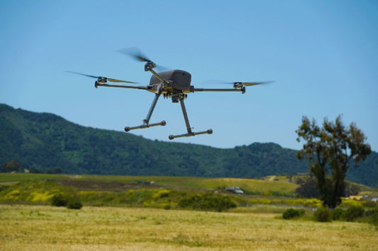
Alta X folds to half its normal size with the push of a finger. The folding linkages stiffen the booms to ensure low vibration and precise & flight characteristics. Alta X is built to carry just about anything with our integrated quick-release system on top and bottom of the aircraft.Quote Now
-
The Alta X's robust construction supports impressive payload capacities, enabling up to 50-minute flights without payload, and 30-minute flights with an 11-pound payload such as the Phoenix LiDAR system.Quote Now
-
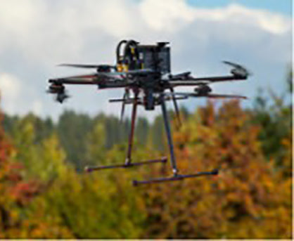
The next evolution in Freefly flight is here! Alta X Gen2 combines the rugged, heavy-lift performance of the Alta X airframe with the cutting-edge flight controller, smart payload interfaces, and seamless workflow integration of Astro Max.Quote Now
-
The next evolution in Freefly flight is here! Alta X Gen2 combines the rugged, heavy-lift performance of the Alta X airframe with the cutting-edge flight controller, smart payload interfaces, and seamless workflow integration of Astro Max.Quote Now
-
MAP61 is Wingtra's most efficient mapping sensor, engineered for both large-scale 2D mapping and high-resolution 3D models.Quote Now
-
The Wingtra RAY Survey 61 is highest quality photogrammetry with survey-grade accuracy.Quote Now
-
The Wingtra RAY INSPECT is an Advanced, Millimeter-Level Crack Detection Mapping Sensor for drones/UAVs.Quote Now
-
The TrueView GO 116S is a handheld mapping system for seamless indoor and outdoor reality capture and high-definition 3D mapping. Featuring 16 channels, three 5MP high-resolution RGB cameras, and a sophisticated 3D LiDAR & Imagery scanner, it easily converts complex environments into digital twins.Quote Now
-
The TrueView GO 132S is an upgraded handheld mapping system for seamless indoor and outdoor reality capture and high-definition 3D mapping. This state-of-the-art device features 32 channels, three 5MP high-resolution RGB cameras, and a sophisticated 3D LiDAR & Imagery scanner, easily converting complex environments into precise digital twins.Quote Now
-
Quick Overview The Inspired Flight IF800 Tomcat is a medium lift drone for many applications such as high-resolution aerial photogrammetry, surveying, search and rescue, and infrastructure inspection. 40-minute flight time with 3 lbs. payload 6 lbs max payload 51 mph max speed 23 knots max wind resistance ONLY AVAILABLE FOR DELIVERY IN TEXAS, OKLAHOMA, NEW MEXICO AND ARIZONA.Quote Now
-
The Inspired Flight IF1200A Blue Herelink is a heavy lift drone for applications such as powerline inspections, precise LiDAR mapping, aerial photogrammetry, rapid emergency response, vital government tasks and much more. 43 minute max flight time 1 lbs max payload weight 56 mph max speed 23 knots wind resistance Many integrated payloads ONLY AVAILABLE FOR DELIVERY IN TEXAS, OKLAHOMA, NEW MEXICO AND ARIZONA.Quote Now
-
The TrueView 655/660 3D Imaging System with Three Cameras is GeoCue’s third generation RIEGL integration built with the miniVUX-3UAV and triple mapping cameras (right, left, nadir) for high accuracy mapping with excellent vegetation penetration and wire detection in a lightweight payload package. Highly accurate drone LiDAR & imagery Drone LiDAR is revolutionizing the way we work, such as creating 3D accurate models and allowing companies to digitize assets like never before. The TrueView™ product series uses a common hardware and software foundation for a family of sensors. The TrueView solution offers innovative drone LiDAR and photogrammetry solutions integrated in lightweight payloads. It allows for fast, easily automated generation of true 3D colorized point clouds, oblique imagery, and orthophotos from a single drone flight. ONLY AVAILABLE FOR DELIVERY IN TEXAS, OKLAHOMA, NEW MEXICO AND ARIZONA. CONTACT SALESPERSON HEREQuote Now
-
TrueView 720 is Geocue’s fourth generation RIEGL integration. This is the system for high point density corridor mapping. Using the RIEGL VUX-120 with 3 lidar scanners (oriented nadir and +10 degrees forward and -10 degrees backward) and 3 oblique/nadir cameras for extremely detailed data collection in one flight path. When scanning power lines, users will be able to capture the poles vertically, front and back. The system can be integrated with drones, airplanes, or helicopters. Ask about custom camera configurations to cover your specific needs. Highly accurate drone LiDAR & imagery Drone LiDAR is revolutionizing the way we work, such as creating 3D accurate models and allowing companies to digitize assets like never before. The TrueView™ product series uses a common hardware and software foundation for a family of sensors. The TrueView solution offers innovative drone LiDAR and photogrammetry solutions integrated in lightweight payloads. It allows for fast, easily automated generation of true 3D colorized point clouds, oblique imagery, and orthophotos from a single drone flight. ONLY AVAILABLE FOR DELIVERY IN TEXAS, OKLAHOMA, NEW MEXICO AND ARIZONA. CONTACT SALESPERSON HEREQuote Now
-
DJI Matrice 400, the enterprise flagship drone platform, boasts an impressive 59-minute flight time, a payload capacity of up to 6 kg , and integrated rotating LiDAR and mmWave radar for power-line-level obstacle sensing.Quote Now
-
The Matrice 4E wide-angle camera supports rapid 0.5-second interval shooting in both orthophoto and oblique photography modes, enabling high-speed aerial surveying from multiple angles. Additionally, the mapping flight speed can reach up to 21 meters per second, significantly enhancing work efficiency.Quote Now

Item added to your cart