877.309.4099
 Contact Sales
 877.309.4099
 Contact Sales
-
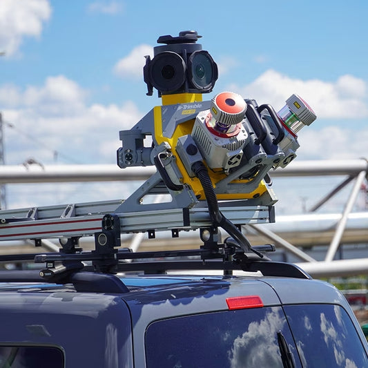
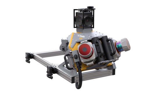
The Trimble® MX90 system is part of a complete field-to-finish mobile mapping solution that combines leading-edge hardware with intuitive field software and an integrated office software workflow. Leverage your large-scale mobile mapping projects with the Trimble MX90, which delivers unmatched GNSS performance in challenging urban and rural environments from the Trimble ProPoint® engine.
-
Sodex SDX-Systems are engineered for the demanding conditions of real-world construction—rugged, reliable, and ready for any challenge. Perfect for: Mobile mapping, quarries, storage facilities, and more—designed for use on cars or wheel loaders.
-
Sodex SDX‑PocketScan is a compact, handheld scanner that enables you to perform convenient, accurate as‑built documentation by capturing high‑quality 3D data using a smartphone.
-
The MX9 AP60 Dual Head is a complete field-to-finish mobile mapping solution and uses the highest grade commercial IMU on the market. This system comes with the AP60 Trimble IMU with GNSS antenna, Dual Laser configuration lidar sensors, 360 Spherical camera, Dual Forward facing oblique cameras and a single Backward down facing Oblique camera. Additional Options for this system include GAMS and DMI. The MX9 is a complete field-to-finish mobile mapping solution combining state-of-the-art, advanced hardware with intuitive field software and a reliable, efficient office software workflow. The MX9 mounts on top of a vehicle and rapidly captures dense point clouds and images—both panoramic and multi-angle. Rich corridor data can be collected at highway speeds, significantly improving data collection on busy highways and avoiding costly lane closures. It is the next-generation solution for your needs today. For more information, see www.allterracentral.com/mx9. ONLY AVAILABLE FOR DELIVERY IN TEXAS, OKLAHOMA, AND ARIZONA. CONTACT SALESPERSON HERESold out
-
The Looq platform helps users accelerate work with a seamless process for capturing, analyzing, and delivering reliable data for topographic mapping and modeling transmission and distribution (T&D) assets. This camera-based data capture technology is supported by sophisticated AI algorithms and provides superior spatial resolution and rapid data processing. The Looq Platform provides one of the most capable 3D computer vision algorithms available to date.

Item added to your cart