877.309.4099
 Contact Sales
 877.309.4099
 Contact Sales
-
WingtraCLOUD streamlines mapping workflows, enabling teams to plan, sync, and collaborate efficiently for reliable, high-quality results.Quote Now
-
The Wingtra RAY INSPECT is an Advanced, Millimeter-Level Crack Detection Mapping Sensor for drones/UAVs.Quote Now
-
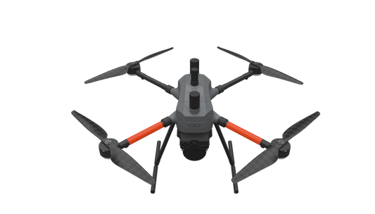
The Wingtra RAY Survey 61 is highest quality photogrammetry with survey-grade accuracy.Quote Now
-
MAP61 is Wingtra's most efficient mapping sensor, engineered for both large-scale 2D mapping and high-resolution 3D models.Quote Now
-
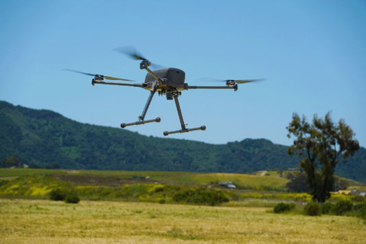
WingtraRAY redefines aerial surveying by guaranteeing mission success on the very first flight—whether you’re navigating tight urban corridors or vast rural expanses—while dramatically cutting turnaround times and operational overhead. Its modular, all-in-one design scales effortlessly from millimeter-level inspections to large-area mapping, so you can serve more clients and tackle a wider range of projects with a single versatile platform.Quote Now
-
Quick Overview The Inspired Flight IF800 Tomcat is a medium lift drone for many applications such as high-resolution aerial photogrammetry, surveying, search and rescue, and infrastructure inspection. 40-minute flight time with 3 lbs. payload 6 lbs max payload 51 mph max speed 23 knots max wind resistance ONLY AVAILABLE FOR DELIVERY IN TEXAS, OKLAHOMA, NEW MEXICO AND ARIZONA.Quote Now
-
The Inspired Flight IF1200A Blue Herelink is a heavy lift drone for applications such as powerline inspections, precise LiDAR mapping, aerial photogrammetry, rapid emergency response, vital government tasks and much more. 43 minute max flight time 1 lbs max payload weight 56 mph max speed 23 knots wind resistance Many integrated payloads ONLY AVAILABLE FOR DELIVERY IN TEXAS, OKLAHOMA, NEW MEXICO AND ARIZONA.Quote Now
-
LP360 Drone - UAV LiDAR and photogrammetry data processingProcess, analyze, and maximize drone survey data, producing valuable information and deliverables Drone LiDAR and photo processing workflow made simple Intuitive workflow Multi-flight import and processing GIS interface allowing combination with other geospatial data Powerful point cloud visualization with multiple and synchronized windows ONLY AVAILABLE FOR DELIVERY IN TEXAS, OKLAHOMA, NEW MEXICO AND ARIZONA. CONTACT SALESPERSON HEREQuote Now
-
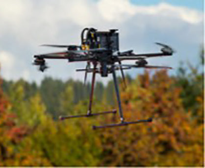
THE MOST COMPACT SURVEY-GRADE DRONE LiDAR SURVEYING EQUIPMENT ON THE MARKET: EasyOneLiDARUHR+ EasyOne LiDAR UHR+ offers some significant upgrades to the UHR and UHR Lite. The Hesai Pandar M2X sensor adds an additional return for impressive density and 40 m of increased range while holding the same accuracies. ultra-high resolution via a 32-channel LiDAR sensor, fully integrated with an improved 72.5° field of view camera. This translates to more point density, better detail, and improved deliverables. The survey equipment, LP360 Drone software, workflow, training, and support work together to make you more productive than ever. Built upon Microdrone’s 4th-gen drone technology, all EasyOne systems are more compact, more optimized, lighter, safer and more efficient. This system delivers integration unmatched in the drone surveying industry, making it easier than ever for you to plan, fly, collect, process and visualize your geospatial data projects. It includes a perpetual license of LP360 Drone software for post-processing your data. LP360 Drone is a powerful ecosystem that will enable you to quickly and efficiently process geospatial data. Your system will include LP360 Drone, as well as Strip Align and Desktop Photo Add-Ons. ONLY AVAILABLE FOR DELIVERY IN TEXAS, OKLAHOMA, NEW MEXICO AND ARIZONA. CONTACT SALESPERSON HEREQuote Now
-
MICRODRONES’ BEST LiDAR PAYLOAD FROM THE 1000 SERIES, NOW AVAILABLE ON OUR NEW AIRFRAME: EasyOneLiDARUHR & UHR LiteSMALLER, SAFER AND EASY TO USE EasyOne LiDAR UHR means ultra-high resolution via a 32-channel LiDAR sensor, fully integrated with an improved 72.5° field of view camera. This translates to more point density, better detail, and improved deliverables. The survey equipment, LP360 Drone software, workflow, training, and support work together to make you more productive than ever. Built upon Microdrone’s 4th-gen drone technology, all EasyOne systems are more compact, more optimized, lighter, safer and more efficient. This system delivers integration unmatched in the drone surveying industry, making it easier than ever for you to plan, fly, collect, process and visualize your geospatial data projects. It includes a perpetual license of LP360 Drone software for post-processing your data. LP360 Drone is a powerful ecosystem that will enable you to quickly and efficiently process geospatial data. Your system will include LP360 Drone, as well as Strip Align and Desktop Photo Add-Ons. Don’t need the full resolution of 32-channel UHR? We offer a cost competitive UHR Lite configuration, delivering 16 channels of LiDAR that can easily be upgraded later via a firmware update. ONLY AVAILABLE FOR DELIVERY IN TEXAS, OKLAHOMA, NEW MEXICO AND ARIZONA. CONTACT SALESPERSON HEREQuote Now
-
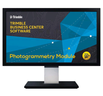
Manage aerial survey and mapping projects from fly to finish. The Trimble® Business Center (TBC) aerial photogrammetry solution brings advanced aerial photogrammetry workflow capabilities together with existing survey workflow and data processing features. Process + create deliverables with Trimble + third-party UAS data in TBC + UASMaster. Note: Each Trimble® Business Center (TBC) Module is designed to support a group of workflows around a single topic. Modules are add-ons to an edition of Trimble Business Center. ONLY AVAILABLE FOR OUR CUSTOMERS IN TEXAS, OKLAHOMA AND ARIZONA Trimble Business Center Aerial Survey - Annually, Per Seat. This is a downloadable product and No Media will be shipped. (An AllTerra Central Salesperson will contact after purchase and provide an installation code.)Quote Now
-
TrueView 720 is Geocue’s fourth generation RIEGL integration. This is the system for high point density corridor mapping. Using the RIEGL VUX-120 with 3 lidar scanners (oriented nadir and +10 degrees forward and -10 degrees backward) and 3 oblique/nadir cameras for extremely detailed data collection in one flight path. When scanning power lines, users will be able to capture the poles vertically, front and back. The system can be integrated with drones, airplanes, or helicopters. Ask about custom camera configurations to cover your specific needs. Highly accurate drone LiDAR & imagery Drone LiDAR is revolutionizing the way we work, such as creating 3D accurate models and allowing companies to digitize assets like never before. The TrueView™ product series uses a common hardware and software foundation for a family of sensors. The TrueView solution offers innovative drone LiDAR and photogrammetry solutions integrated in lightweight payloads. It allows for fast, easily automated generation of true 3D colorized point clouds, oblique imagery, and orthophotos from a single drone flight. ONLY AVAILABLE FOR DELIVERY IN TEXAS, OKLAHOMA, NEW MEXICO AND ARIZONA. CONTACT SALESPERSON HEREQuote Now
-
The TrueView 535 builds upon the success of our best-selling TrueView 515. We've added a third LiDAR beam return to improve vegetation capture detail, a third nadir camera to improve photogrammetry deliverables, and a longer usable LiDAR range to increase flexibility. Highly accurate drone LiDAR & imagery Drone LiDAR is revolutionizing the way we work, such as creating 3D accurate models and allowing companies to digitize assets like never before. The TrueView™ product series uses a common hardware and software foundation for a family of sensors. The TrueView solution offers innovative drone LiDAR and photogrammetry solutions integrated in lightweight payloads. It allows for fast, easily automated generation of true 3D colorized point clouds, oblique imagery, and orthophotos from a single drone flight. ONLY AVAILABLE FOR DELIVERY IN TEXAS, OKLAHOMA, NEW MEXICO AND ARIZONA. CONTACT SALESPERSON HEREQuote Now
-
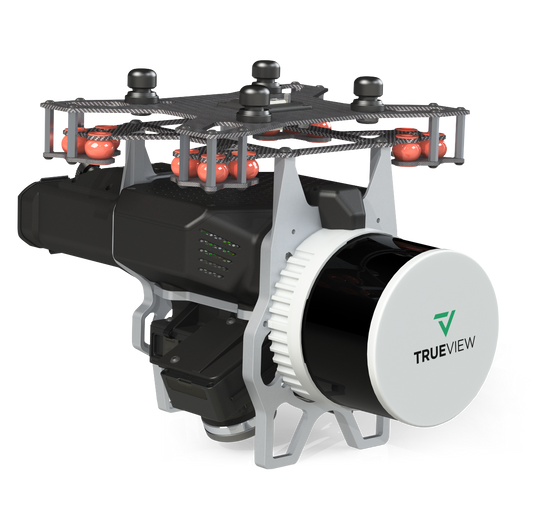
GeoCue's TrueView 515 is simply the best performing LIDAR/Camera system in the mid-price range. This compact 3D Imaging System has impeccable definition along wires, superior ground cover beneath vegetation and sensitivity like we’ve never seen in this class system. Highly accurate drone LiDAR & imagery Drone LiDAR is revolutionizing the way we work, such as creating 3D accurate models and allowing companies to digitize assets like never before. The TrueView™ product series uses a common hardware and software foundation for a family of sensors. The TrueView solution offers innovative drone LiDAR and photogrammetry solutions integrated in lightweight payloads. It allows for fast, easily automated generation of true 3D colorized point clouds, oblique imagery, and orthophotos from a single drone flight. ONLY AVAILABLE FOR DELIVERY IN TEXAS, OKLAHOMA, NEW MEXICO AND ARIZONA. CONTACT SALESPERSON HEREQuote Now
-
The TrueView 655/660 3D Imaging System with Three Cameras is GeoCue’s third generation RIEGL integration built with the miniVUX-3UAV and triple mapping cameras (right, left, nadir) for high accuracy mapping with excellent vegetation penetration and wire detection in a lightweight payload package. Highly accurate drone LiDAR & imagery Drone LiDAR is revolutionizing the way we work, such as creating 3D accurate models and allowing companies to digitize assets like never before. The TrueView™ product series uses a common hardware and software foundation for a family of sensors. The TrueView solution offers innovative drone LiDAR and photogrammetry solutions integrated in lightweight payloads. It allows for fast, easily automated generation of true 3D colorized point clouds, oblique imagery, and orthophotos from a single drone flight. ONLY AVAILABLE FOR DELIVERY IN TEXAS, OKLAHOMA, NEW MEXICO AND ARIZONA. CONTACT SALESPERSON HEREQuote Now

Item added to your cart