QUICK
SHIP
SHIP
SAME DAY SHIPPING WHEN ORDERED BY 2:00PM LOCAL TIME
98% Ships same day-99% Arrives in 1-2 business day
Microdrones mdLiDAR 1000SICK aaS Payload (no airframe) - Used – Good
Quick Overview
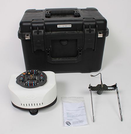
mdLiDAR 1000SICK aaS is a fully integrated system for producing 3D point clouds optimized for land surveying, construction, oil & gas, and mining applications. mdLiDAR1000 aaS consistently provides an accuracy of 6 cm (0.2 ft) when flown at 40 m (130 ft) at a speed of 3 m/s (6.7 mph). Microdrones has developed an end-to-end LiDAR solution combining a drone, a LiDAR payload, a fully integrated software workflow, and world class support to consistently provide quality deliverables. The mdLiDAR 1000SICK aaS Payload is compatible with the md4-1000 Version C platform only. Includes a 30-Day Warranty. CALL 877-300-9659 if you have any questions (mention you saw it on the website).
Microdrones mdLiDAR 1000SICK aaS Payload Includes:
- Microdrones mdLiDAR 1000SICK aaS Payload
- TCQM (Top Cover Quick Mount) with AV-14 Antenna
- Microdrones Rugged Transport Case
- 30-Day Warranty
NOT AVAILABLE FOR DELIVERY IN CALIFORNIA.
Code: 050922
SKU
U_MDLIDAR_1000SICK-G
In stock
Now Only
$4,995.00
Regular Price
$20,000.00

mdLiDAR 1000SICK aaS is a fully integrated system for producing 3D point clouds optimized for land surveying, construction, oil & gas, and mining applications. mdLiDAR1000 aaS consistently provides an accuracy of 6 cm (0.2 ft) when flown at 40 m (130 ft) at a speed of 3 m/s (6.7 mph). Microdrones has developed an end-to-end LiDAR solution combining a drone, a LiDAR payload, a fully integrated software workflow, and world class support to consistently provide quality deliverables. The mdLiDAR 1000SICK aaS Payload is compatible with the md4-1000 Version C platform only. Includes a 30-Day Warranty. CALL 877-300-9659 if you have any questions (mention you saw it on the website).
Microdrones mdLiDAR 1000SICK aaS Payload Includes:
- Microdrones mdLiDAR 1000SICK aaS Payload
- TCQM (Top Cover Quick Mount) with AV-14 Antenna
- Microdrones Rugged Transport Case
- 30-Day Warranty
Microdrones Payload mdLiDAR 1000SICK aaS:
• LiDAR Sensor: SICK LD-MRS4
• Camera: FLIR 5MP Global Shutter
• Georeferencing: APX-15 UAV
System Accuracy
• LiDAR Point Cloud:
• Horizontal: 6 cm
• Vertical: 6 cm
• Photogrammetry:
• Horizontal: 1-2 pixels
• Vertical: 3-4 pixels
Code: 050922