Trimble MX9 AP60 Dual Head, Mobile Mapping for Large-Scale Scanning & Mapping Missions
Quick Overview
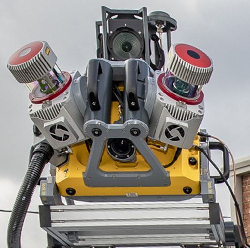
The MX9 AP60 Dual Head is a complete field-to-finish mobile mapping solution and uses the highest grade commercial IMU on the market. This system comes with the AP60 Trimble IMU with GNSS antenna, Dual Laser configuration lidar sensors, 360 Spherical camera, Dual Forward facing oblique cameras and a single Backward down facing Oblique camera. Additional Options for this system include GAMS and DMI.
The MX9 is a complete field-to-finish mobile mapping solution combining state-of-the-art, advanced hardware with intuitive field software and a reliable, efficient office software workflow. The MX9 mounts on top of a vehicle and rapidly captures dense point clouds and images—both panoramic and multi-angle. Rich corridor data can be collected at highway speeds, significantly improving data collection on busy highways and avoiding costly lane closures. It is the next-generation solution for your needs today.
For more information, see www.allterracentral.com/mx9.
ONLY AVAILABLE FOR DELIVERY IN TEXAS, OKLAHOMA, AND ARIZONA.
SKU
T001445
Delivery in 4 - 6 weeks

Key Features
- New Riegl VUX scanners that produce 3.6 million measurements per second
- At lower scan rates, the range captures data up to 475 M.
- 12 MP camera planar cameras for object inspection and mapping.
- Very high point cloud density with complimentary immersive imagery
- Advanced Trimble GNSS and Inertial technology
- Lightest and most compact premium mobile mapping system
- Simple installation and browser based operation from any smart device
- Compatible with existing Trimble software and workflows
- Enhanced remote support capabilities
- Supported by Trimble Business Center (TBC) Mobile Mapping for efficient data processing
- Trimble MX software for feature extraction workflows and data publishing
Applications
- Whatever the application, the Trimble MX9 quickly and efficiently collects the highly precise and powerful data you need, and delivers it across your organization.
- Whether you are a city planner, work for a department of transportation or are a service provider, count on it for generating deliverables such as:
- Road assets
- Cross sections
- 3D models
- GIS layers
- Elevation models
- Volumetric analysis