877.309.4099
 Contact Sales
 877.309.4099
 Contact Sales
-
-
-
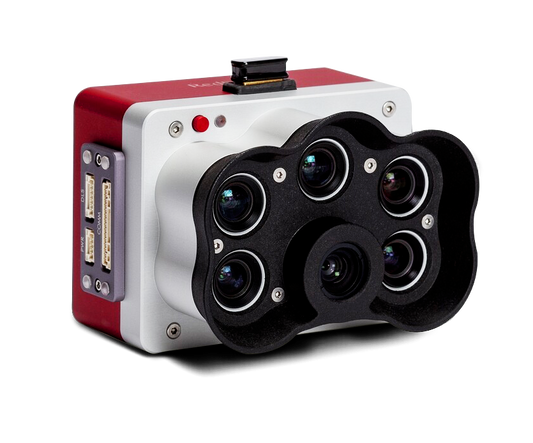
MicaSense RedEdge-PThe MicaSense RedEdge Panchromatic (RE-P) is our premium multispectral camera, which combines a panchromatic sensor with five narrow bands to produce high-resolution multispectral and RGB from one flight for advanced analytics.Quote Now
-
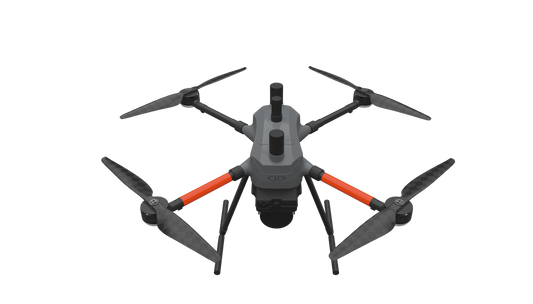
MICRODRONES’ BEST LiDAR PAYLOAD FROM THE 1000 SERIES, NOW AVAILABLE ON OUR NEW AIRFRAME: EasyOneLiDARUHR & UHR LiteSMALLER, SAFER AND EASY TO USE EasyOne LiDAR UHR means ultra-high resolution via a 32-channel LiDAR sensor, fully integrated with an improved 72.5° field of view camera. This translates to more point density, better detail, and improved deliverables. The survey equipment, LP360 Drone software, workflow, training, and support work together to make you more productive than ever. Built upon Microdrone’s 4th-gen drone technology, all EasyOne systems are more compact, more optimized, lighter, safer and more efficient. This system delivers integration unmatched in the drone surveying industry, making it easier than ever for you to plan, fly, collect, process and visualize your geospatial data projects. It includes a perpetual license of LP360 Drone software for post-processing your data. LP360 Drone is a powerful ecosystem that will enable you to quickly and efficiently process geospatial data. Your system will include LP360 Drone, as well as Strip Align and Desktop Photo Add-Ons. Don’t need the full resolution of 32-channel UHR? We offer a cost competitive UHR Lite configuration, delivering 16 channels of LiDAR that can easily be upgraded later via a firmware update. ONLY AVAILABLE FOR DELIVERY IN TEXAS, OKLAHOMA, NEW MEXICO AND ARIZONA. CONTACT SALESPERSON HEREQuote Now
-
THE MOST COMPACT SURVEY-GRADE DRONE LiDAR SURVEYING EQUIPMENT ON THE MARKET: EasyOneLiDARUHR+ EasyOne LiDAR UHR+ offers some significant upgrades to the UHR and UHR Lite. The Hesai Pandar M2X sensor adds an additional return for impressive density and 40 m of increased range while holding the same accuracies. ultra-high resolution via a 32-channel LiDAR sensor, fully integrated with an improved 72.5° field of view camera. This translates to more point density, better detail, and improved deliverables. The survey equipment, LP360 Drone software, workflow, training, and support work together to make you more productive than ever. Built upon Microdrone’s 4th-gen drone technology, all EasyOne systems are more compact, more optimized, lighter, safer and more efficient. This system delivers integration unmatched in the drone surveying industry, making it easier than ever for you to plan, fly, collect, process and visualize your geospatial data projects. It includes a perpetual license of LP360 Drone software for post-processing your data. LP360 Drone is a powerful ecosystem that will enable you to quickly and efficiently process geospatial data. Your system will include LP360 Drone, as well as Strip Align and Desktop Photo Add-Ons. ONLY AVAILABLE FOR DELIVERY IN TEXAS, OKLAHOMA, NEW MEXICO AND ARIZONA. CONTACT SALESPERSON HEREQuote Now
-
Regular price $110.00Regular priceUnit price per
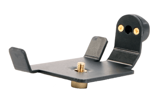
Mounting Bracket for TruPulse 360R and 200X
Mounting Bracket for TruPulse 360R and 200X -
Used for mounting an extension onto a tribrach adapter and allowing GPS antennas or Laser Scanners to have a solid base. Mast Extension Large Washer is 3.5 inches in diameter.
-
Regular price $405.00Regular priceUnit price per
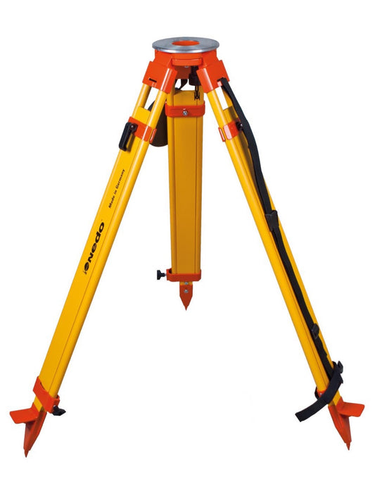
Nedo Surveyors Grade Wooden Tripod - Dual Clamp
Suitable for: Total stations Robotic total stations Digital levels Theodolites Heavy-duty rotating lasers Features: Wooden parts made of finest European hard wood Plastic-coated wooden legs for utmost durability Large round tripod head made of aluminum, powder-coated Dual clamp: quick release and screw clamp Break-proof quick release levers, made of aluminum Snap Cap Brass hinge pins for extra stability Tripod shoes made of aluminum w/ replaceable steel points Carrying strap In accordance with ISO 12858-2-H Strapless-Go: Retract-and-go transport locking system -
-
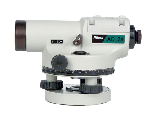
The Nikon AC-2S 24x telescope has a 30mm objective lens for clear, bright images in an erect and unreversed orientation. The built-in compensator automatically levels the line of sight over a wide compensation range of ±16 inches with a setting accuracy of ±0.5 inch and minimum focusing distance of 0.75 meters/2.46 feet, standard deviation for a 1-km double-run level is just ±2.5mm. HGA42210.Rent Now
-
Regular price $555.00Regular priceUnit price per
Nikon AC-2S 24X Automatic Level (360 degree)
The Nikon AC-2S 24x telescope has a 30mm objective lens for clear, bright images in an erect and unreversed orientation. The built-in compensator automatically levels the line of sight over a wide compensation range of ±16 inches with a setting accuracy of ±0.5 inch and minimum focusing distance of 0.75 meters/2.46 feet, standard deviation for a 1-km double-run level is just ±2.5mm. HGA42210. -
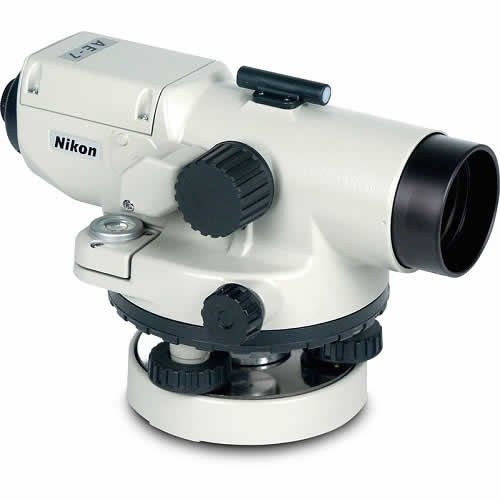
Nikon AE-7 Series auto levels feature waterproof, high-power telescopes that help you make precise measurements even in the wettest conditions. Precise measurements from waterproof, high-power telescopes. AL-NIKON-AE-7.Rent Now
-
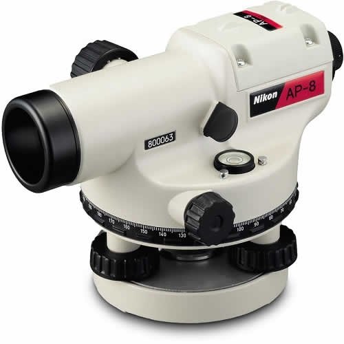
The Nikon AP-8 automatic level features a 28x telescope with a 30mm objective lens for clear, bright images in an erect and unreversed orientation. With a built-in compensator, it automatically levels the line of sight over a wide compensation range of ±16 inches with a setting accuracy of ±0.5 inch.Rent Now
-
Regular price $1,020.00Regular priceUnit price per
Nikon AP-8 Automatic Level, 360 Degrees, 28X
The Nikon AP-8 automatic level features a 28x telescope with a 30mm objective lens for clear, bright images in an erect and unreversed orientation. With a built-in compensator, it automatically levels the line of sight over a wide compensation range of ±16 inches with a setting accuracy of ±0.5 inch. -
Sold outRegular price $95.00Regular priceUnit price per
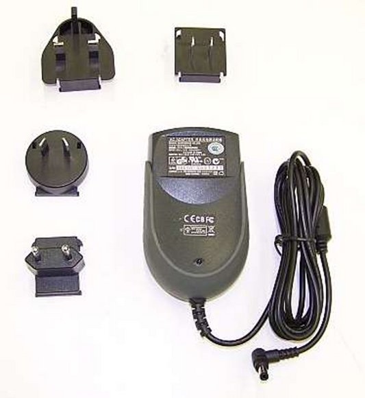
NIKON External Dual Charger Cord/Adapter
NIKON 53708-00 External Dual Charger Replacement Charger Cord with international adapters. Input: AC100-240V, Output: 5V/4A Compatible with (HQJ27000-TNL) dual bay charger.Sold out -
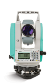
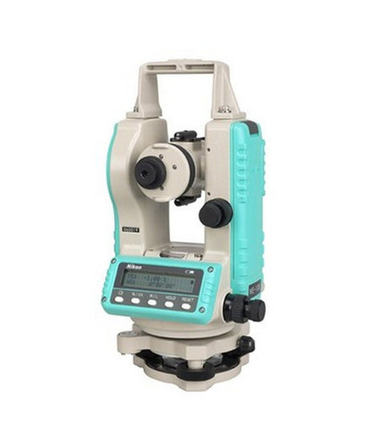
The Nikon N total station offers an advanced EDM in an innovative package, including flexible charging and connectivity options. The Nikon N has a new charger, featuring a USB-C on-the-go connection that lets you recharge via a power bank or car plug so you can recharge batteries even in remote areas. The Total Station File Transfer app and Bluetooth connection let you easily transfer data between the field and office, so your data makes it to the office before you do. Economical and practical, both include bright Nikon optics and rugged reliability, making each of these powerful total stations the right choice for a full range of projects. 2" angle accuracy Dual Display Prism and reflectorless models Fast, accurate EDM Phone App for easy data transfer NFC simplifies bluetooth pairing Power-up anywhere with the USB battery charger
-
Sold outRegular price $4,560.00Regular priceUnit price per
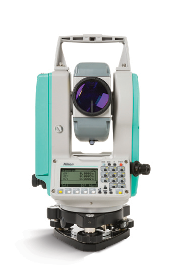
Nikon NE-101 Digital Theodolite
Ease of use, reliability, and durability make the Nikon NE-101 theodolite a smart choice for your general construction, alignment and layout applications. Ideal for concrete form alignment, anchor bolt positioning, and steel column erection. The theodolite enables a number of positioning techniques: 90-degree layout, checking angles, alignment and plumb, as well as short range grade work and leveling.Sold out -
Regular price $135.00Regular priceUnit price per
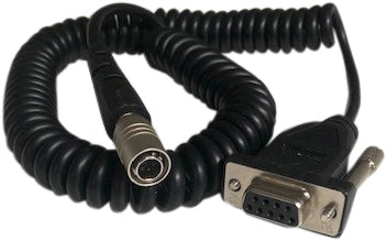
Nikon Total Station to Data Collector Cable
Nikon cable connects your Nikon total station to your TSC3/TSC2/TSCe/Recon/Nomad data collector 9-Pin to Nikon Total Station VIA the RS232 Serial Port connection. -
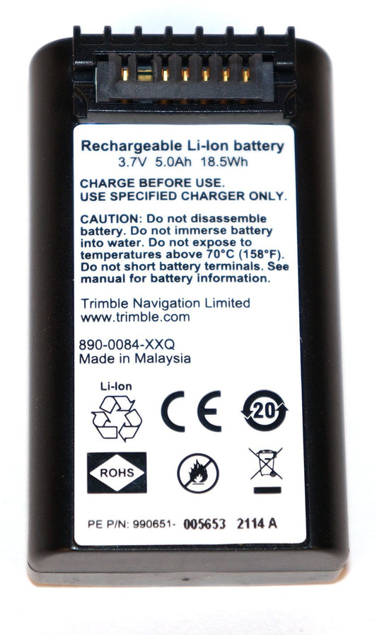
Trimble rechargeable, convenient and long-lasting Li-Ion Battery for Nikon Nivo and Focus 8/6 and Trimble M1/M3 total stations. T

Item added to your cart