877.309.4099
 Contact Sales
 877.309.4099
 Contact Sales
-
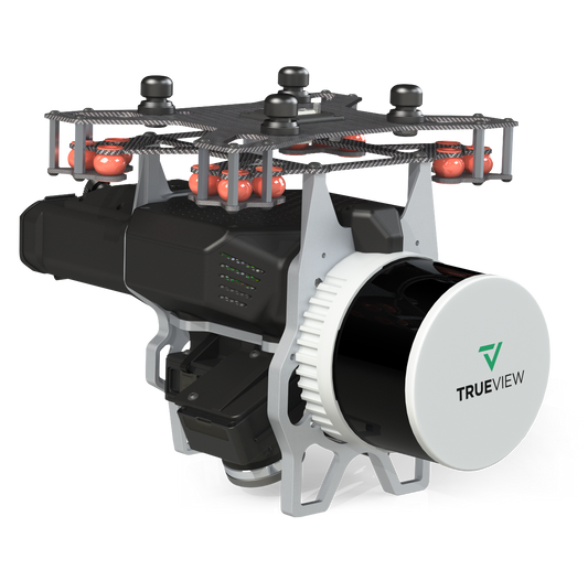
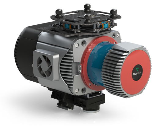
GeoCue and CHC Navigation bring the most efficient and flexible high-end LiDAR to North America with the new TrueView 540. This next generation of LiDAR elevates our mid-range sensor line, offering enhanced density, improved accuracy, and precision, thereby producing a superior point cloud. The TrueView 540 provides users with a Engineering grade sensor powered by LP360 at a mid-range price, marking a significant advancement in LiDAR accessibility and performance.Quote Now
-
Request for Quote
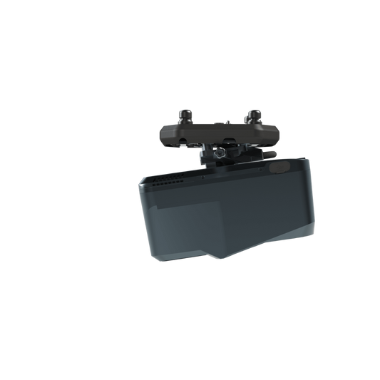
TrueView 539 - Delivering Engineering-Grade Accuracy and Precision in a Lightweight
Building on the success of the TrueView 540, the new TrueView 539 brings advanced engineering-grade surveying capabilities to a wider range of aerial mapping professionals. Designed for those who demand high-quality LiDAR performance in a more affordable package, the TrueView 539 delivers precision and flexibility without compromise.Quote Now -
The TrueView GO 116S is a handheld mapping system for seamless indoor and outdoor reality capture and high-definition 3D mapping. Featuring 16 channels, three 5MP high-resolution RGB cameras, and a sophisticated 3D LiDAR & Imagery scanner, it easily converts complex environments into digital twins.Quote Now
-
The TrueView GO 132S is an upgraded handheld mapping system for seamless indoor and outdoor reality capture and high-definition 3D mapping. This state-of-the-art device features 32 channels, three 5MP high-resolution RGB cameras, and a sophisticated 3D LiDAR & Imagery scanner, easily converting complex environments into precise digital twins.Quote Now
-
The TrueView 655/660 3D Imaging System with Three Cameras is GeoCue’s third generation RIEGL integration built with the miniVUX-3UAV and triple mapping cameras (right, left, nadir) for high accuracy mapping with excellent vegetation penetration and wire detection in a lightweight payload package. Highly accurate drone LiDAR & imagery Drone LiDAR is revolutionizing the way we work, such as creating 3D accurate models and allowing companies to digitize assets like never before. The TrueView™ product series uses a common hardware and software foundation for a family of sensors. The TrueView solution offers innovative drone LiDAR and photogrammetry solutions integrated in lightweight payloads. It allows for fast, easily automated generation of true 3D colorized point clouds, oblique imagery, and orthophotos from a single drone flight. ONLY AVAILABLE FOR DELIVERY IN TEXAS, OKLAHOMA, NEW MEXICO AND ARIZONA. CONTACT SALESPERSON HEREQuote Now
-
TrueView 720 is Geocue’s fourth generation RIEGL integration. This is the system for high point density corridor mapping. Using the RIEGL VUX-120 with 3 lidar scanners (oriented nadir and +10 degrees forward and -10 degrees backward) and 3 oblique/nadir cameras for extremely detailed data collection in one flight path. When scanning power lines, users will be able to capture the poles vertically, front and back. The system can be integrated with drones, airplanes, or helicopters. Ask about custom camera configurations to cover your specific needs. Highly accurate drone LiDAR & imagery Drone LiDAR is revolutionizing the way we work, such as creating 3D accurate models and allowing companies to digitize assets like never before. The TrueView™ product series uses a common hardware and software foundation for a family of sensors. The TrueView solution offers innovative drone LiDAR and photogrammetry solutions integrated in lightweight payloads. It allows for fast, easily automated generation of true 3D colorized point clouds, oblique imagery, and orthophotos from a single drone flight. ONLY AVAILABLE FOR DELIVERY IN TEXAS, OKLAHOMA, NEW MEXICO AND ARIZONA. CONTACT SALESPERSON HEREQuote Now
-
The TrueView 535 builds upon the success of our best-selling TrueView 515. We've added a third LiDAR beam return to improve vegetation capture detail, a third nadir camera to improve photogrammetry deliverables, and a longer usable LiDAR range to increase flexibility. Highly accurate drone LiDAR & imagery Drone LiDAR is revolutionizing the way we work, such as creating 3D accurate models and allowing companies to digitize assets like never before. The TrueView™ product series uses a common hardware and software foundation for a family of sensors. The TrueView solution offers innovative drone LiDAR and photogrammetry solutions integrated in lightweight payloads. It allows for fast, easily automated generation of true 3D colorized point clouds, oblique imagery, and orthophotos from a single drone flight. ONLY AVAILABLE FOR DELIVERY IN TEXAS, OKLAHOMA, NEW MEXICO AND ARIZONA. CONTACT SALESPERSON HEREQuote Now
-
GeoCue's TrueView 515 is simply the best performing LIDAR/Camera system in the mid-price range. This compact 3D Imaging System has impeccable definition along wires, superior ground cover beneath vegetation and sensitivity like we’ve never seen in this class system. Highly accurate drone LiDAR & imagery Drone LiDAR is revolutionizing the way we work, such as creating 3D accurate models and allowing companies to digitize assets like never before. The TrueView™ product series uses a common hardware and software foundation for a family of sensors. The TrueView solution offers innovative drone LiDAR and photogrammetry solutions integrated in lightweight payloads. It allows for fast, easily automated generation of true 3D colorized point clouds, oblique imagery, and orthophotos from a single drone flight. ONLY AVAILABLE FOR DELIVERY IN TEXAS, OKLAHOMA, NEW MEXICO AND ARIZONA. CONTACT SALESPERSON HEREQuote Now

Item added to your cart